Point Sublime Overnighter
Route Guide
Location
Grand Canyon - North Rim, Arizona, USA
Physical Difficulty*
6/10
Days to Ride
2 - 3 Days
Technical Difficulty*
6/10
Length
71 Miles
Tire Size
Recommended: 2.3"-2.8"
Seasons
Best: May 15** - Mid-Oct.
Not Possible: Late October - May 14**
Elevation Gain
6,658 Feet
Primary Surfaces
Rough Gravel; 4x4 Roads; Singletrack
*Based on Bikepacking Roots’ Route Rating Scale
**Bicycles prohibited on North Rim Grand Canyon NP roads from Dec. 1 until May 15.
2. Route Description
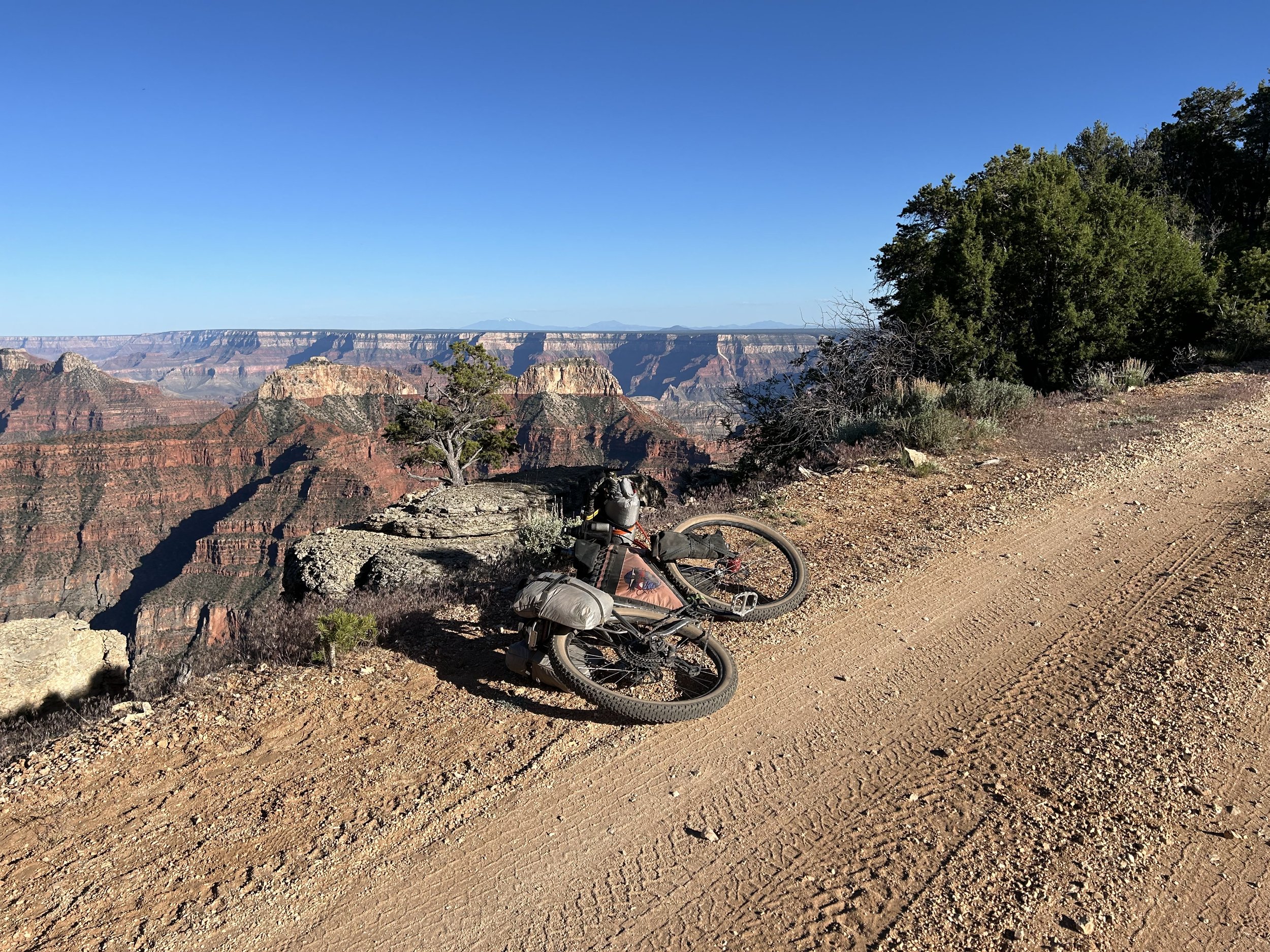
Point Sublime Overnighter takes bikepackers on a loop out to remote and iconic Point Sublime in Grand Canyon National Park. This viewpoint is famous for its campsite on the North Rim where a night is spent on a fin of land jutting into the chasm.
The route provides opportunities to see both the the inner Canyon gorge and its desertscape as well as the subalpine forests and meadows strewn across the Kaibab Plateau. Start at Demotte before climbing to the route high point of 9200 feet. Riders then descend towards Kanabownits Canyon and its namesake historic lookout tower where a climb provides vast views from forest interior to Grand Canyon edge. Bike out to Point Sublime for a night of camping (backcountry permit required). On your way back the next morning, stop to gaze out at Crystal Canyon before starting a chunky and eroded dirt track through thicks of ponderosa and aspen. You'll cross the sprawling Basin with its wild bison herd before eventually entering the North Rim Village. Spend another night camped rim-side at the wonderful hiker-biker site in the North Rim Campground along with more Grand Canyon views at Bright Angel Point. The next day starts with riding beautiful Arizona Trail singletrack that flows across broad meadows followed by another fire tower stop at North Rim Lookout. Finally, bikepackers merge with well-maintained FR 610 to finish the loop back at Demotte.
Highlights:
Biking out to and camping at Point Sublime in Grand Canyon National Park
Kanabownits and North Rim Lookout Towers
Riding relatively smooth Arizona Trail singletrack across subalpine meadows
Additional Grand Canyon viewpoints at Crystal Canyon and Bright Angel Point
Sitting on chairs along the back porch of the North Kaibab Lodge to enjoy viewpoints off the North Rim
Seeing wild bison in the Basin
Biking along the Kaibab High Point at 9200 Feet
Possible hikes at the Widforss and North Kaibab Trails
Camping at probably the best site in the North Rim Campground at the hiker-biker site
3. Map and GPX
-
Purple = Improved Dirt Surface (Frequently Maintained, Usually Smoother)
Red = Rugged Dirt Surface (Infrequently Maintained, Typically Rougher/Rockier)
Brown = Primitive Dirt Surface (Rarely/Never Maintained, Particularly Rocky/Rutted/Eroded)
Black = Singletrack
Yellow = Hiking Trail (must park bike and hike/walk)
Blue = Vehicular Pavement
Green = Dirt Multi-Use Path


4. Route Difficulty, Surface Conditions, and Direction to Ride
Route Difficulty
Physical Difficulty = 6/10 (Rugged terrain with frequent climbs, some of which may be steep and unrelenting)
Technical Difficulty = 6/10 (Continuous sections of track may be rocky, loose, and steep; (e.g., 4×4 roads or singletrack in rugged/rocky terrain) suitable for riders with intermediate off-road experience)
The technical difficulty of the route is due to the abundant spread of surfaces that range from pavement, to smooth dirt, to chunky doubletrack. There are stretches with several miles of rugged and rocky tread, especially between the turn to Point Sublime and the Widforss Trailhead. There are also miles of gorgeous wide dirt roads coursing through the woods.
The physical difficulty is mostly due to the climbing. This route is hilly and can be steep in short sections. Point Sublime Overnighter travels across the mountainous folds of the Kaibab Plateau; riders should expect rolling terrain that frequently ascends and descends ridges and canyons. Although the route is gradual on average, there are some sections featuring steep grades.
Noteworthy Climbs
The climb from Point Sublime to the Widforss Trailhead
Ascent up the AZT singletrack to the North Rim Lookout
Surface Conditions
Point Sublime Overnighter travels down a trove of Forest Service roads and old doubletrack. Some of the Forest Service roads are regularly maintained, wide, lightly graveled, and sometimes hero dirt. The ride out towards the Park Boundary carries riders down smooth-to-chunky-to-decayed doubletrack. The dirt roads in Grand Canyon National Park are especially poorly maintained. I've been told the USFS puts spending priority on their unpaved roads while the NPS does not. Overall, there can be extended sections of washboard, ruts, and chunk with ample babyheads. These roads are often littered with tree blowdowns come early summer. The deadfall will get removed, but anyone traveling in the early season may have to go around/over trees until agencies clear them. The singletrack along the Arizona Trail is flowy, relatively non-technical, and pleasant trail riding.
Noteworthy Primitive, Rocky Surfaces
The section between Crystal Canyon viewpoint and the Widforss Trailhead
Direction to Ride
The route is intended to be ridden in a counterclockwise direction.
5. Parking
Park your car overnight at the Kaibab Lodge (contact ahead to get permission - (928) 638-2389, info@KaibabLodge.com), or ride up the route a bit on FR 22 to leave it at a pull-out in the woods.
6. Water and Food
Water Reliability
Water is scarce along this route. The Kaibab National Forest is considered the driest national forest in the United States. Although the North Rim is higher than the South Rim and consequently receives an average of 25.8 inches of moisture a year, most quickly percolates through the porous rock of Kaibab Limestone that makes up the upper layers of this area. Plan to carry several liters of water, enough to last you at least 24 hours to dry camp at Point Sublime and make it to the North Kaibab Trailhead faucet the next day.
Definite water can be found at Demotte and the North Rim Village area in GCNP. Beyond that, water is mostly found in dirt cattle tanks, springs, and unreliable seasonal creeks. This route requires riders to dry camp. Be prepared to load up at water sources so that you can camp far away from them.
Food Resupplies
Food resupplies are located at Demotte and the North Rim Village area.
7. Fees and Permits
Kaibab National Forest has no fees.
Grand Canyon National Park requires a fee for entry. No cash, credit/debit only. ($35 for a vehicle; $20 for a bicycle).
8. Important Information
Hunting Season:
Starts in September and goes through December. Hunters will mostly be seeking deer and elk. Expect to see more trucks, backcountry campers, ATVs, and individuals on foot. WEAR ORANGE and make yourself visible as you ride. Be smart and be seen during hunting season. Wildlife Tanks may have more hunters scoping them out.
Dark Skies:
Grand Canyon National Park is an International Dark Sky Park. This means that you can expect to have anywhere between Bortle Class 1 - 3 night skies overhead (even better night viewing during a new moon). The Bortle Class Scale is used to rate night skies on their clarity and lack of light pollution. A Bortle Class 1 is the darkest possible and there are several locations along these routes where, should you camp, you will have this level of darkness. Here, night skies will be virtually unimpeded by artificial light. You can use the following sites to explore more:
Black Bears:
There are black bears which means you need to properly store your food at night using a bear-aware method.
Bugs:
Mosquitoes and biting flies can be abundant on this route in the forest valleys and drainages where moisture and standing water collect. This will be especially true in the summer and early fall, especially if precipitation has been plentiful.
Fences:
There may be "cowboy fences" on this route which consist of barbed wire wrapped around vertical wooden branches that are strung across roads. They can be opened by removing a loop of wire on one side. Most importantly, leave fences as you found them; re-close them if they were closed.
Hantavirus and Plague:
Bubonic plague and hantavirus are frequent enough amongst the rodent population that you should avoid their saliva, feces, urine, and direct bodily contact. Be careful when entering old cabins and caves where droppings are plentiful and ventilation is limited. These are prime areas for possible contraction of these diseases.
9. North Rim Specific Bike Access
No riding singletrack or trails above the rim in Grand Canyon National Park except for the Arizona Trail. You are allowed to cycle on any established dirt roads.
Why May 15th, specifically? Bicycles are prohibited on all Grand Canyon National Park North Rim backcountry roads from December 1 until May 15. No backcountry permits will be issued prior to May 15 for campsites. If starting in the early season, time arrival at the Park boundary to be right on May 15. The Kaibab National Forest permits bicycle travel outside these dates.
10. General Access and Tribal Nations
Bikes are STRICTLY forbidden below the rim in the inner gorge of the Grand Canyon. DO NOT RIDE YOUR BIKE DOWN INTO THE CANYON - you will get fined, it is illegal, and you will hurt the perception and opportunities of other bikepackers on this route. There are certain trails on top that are also off-limits to bikes; this route expressly avoids them. No cross-country travel in Grand Canyon National Park; practicing Leave No Trace means staying on established trails, roads, and paths.
I must note that although this route stays on "public lands," the formation of Grand Canyon National Park and surrounding land designations involved the forced removal of tribes such as the Havasupai, and they have endured legal battles to keep their vastly smaller chunk of land out of their historical precedent. Know the land you are riding on is traditionally theirs, know their current reservation boundaries are smaller than where they historically inhabited, and know where you are riding to keep yourself both legal and respectful.
11. Camping
There is no dispersed camping within the boundaries of Grand Canyon National Park. However, there is an established camping site at the North Rim Campground. The North Rim Campground near the village has a fantastic hiker/biker site for walk-ups arriving by foot or bicycle. The hiker/biker site is shared with other cyclists and backpackers and costs $6 per night per person. The North Rim Campground is conveniently located next to the North Rim General Store and is only a short ride away from the lodging, restaurants, and Post Office (M-F, May 15 - October 15, 8:00 am - 12:00 pm, 1:00 pm - 5:00 pm) in the village.
If you want to stay at the backcountry campsite above the rim at Point Sublime, you will need to reserve backcountry permits through the GCNP Backcountry Information Center or online at Recreation.gov. No backcountry permits will be issued prior to May 15 for campsites. Here are the steps to take to reserve these sites:
Head to Recreation.gov for Grand Canyon National Park Backcountry Permits.
Click "Check Availability" under Available Permits on the right hand side.
Choose the button tab "Above Rim Areas - North Rim" at the top.
Choose the following option:
NH1 - Point Sublime - Campsite
If it's less than 30 days until your planned date to camp here, and the "1-6 people" permit is already taken, you are allowed to choose the "LARGE GROUP" option if it's still available.
If you want to backcountry camp anywhere else above the Rim in Grand Canyon National Park, you'll need to navigate to the same link above and make sure to choose the proper Use Area. This Use Area Map will help you determine which zone is appropriate for your intended backcountry campsite.
Outside of GCNP in the Kaibab National Forest, excellent and numerous dispersed camping abounds. The North Rim is truly one of the most remarkable places for dispersed camping right up against the edge of the Canyon at numerous locations for those making the remote trek out. Just make sure to pay attention to boundary lines between Grand Canyon National Park and the Kaibab National Forest.
12. Sample Route Itinerary
This is a suggested itinerary. Use it as a rough guide for your own planning purposes. Feel free to use it, adapt it, or don't use it all and make your own plans. Plan your trip on this route based on your own strengths, comfortabilities, experiences, wants, and needs.
-
Mileage: 28 Miles
Elevation Gain: 1900 Feet
Water: Nothing Reliable - Carry enough water to get you through tomorrow.
Resupply: None
Camping: Point Sublime (Backcountry Camping Permit required from Grand Canyon National Park)
-
Mileage: 22 Miles
Elevation Gain: 2600 Feet
OPTIONAL: Combine Days 2 and 3 and cover 42 miles and 4700 feet of gain to finish.
Water: North Kaibab TH faucet; North Rim Campground, North Rim Village
Resupply: North Rim General Store
Camping: Hiker/Biker site at the North Rim Campground
-
Mileage: 20 Miles
Elevation Gain: 2100 Feet
OPTIONAL: Combine Days 2 and 3 and cover 42 miles and 4700 feet of gain to finish.
Water: North Kaibab TH faucet; Water jug at North Rim Entrance Station next to AZT, Demotte
Resupply: North Rim Country Store or Kaibab Lodge in Demotte
Camping: Finish! Demotte Campground, Kaibab Lodge, Dispersed Camping in woods nearby