East Rim Overnighter
Route Guide
Location
Grand Canyon - North Rim, Arizona, USA
Physical Difficulty*
5/10
Days to Ride
2 Days
Technical Difficulty*
5/10
Length
66 Miles
Tire Size
Recommended: 2.2"-2.6"
Seasons
Best: Late-May - Mid-Oct.
Elevation Gain
4,712 Feet
Primary Surfaces
Smooth Gravel; Rough Gravel; Singletrack
*Based on Bikepacking Roots’ Route Rating Scale
2. Route Description
East Rim Overnighter is a chance to bike out to four capes on the eastern portion of the Kaibab Plateau. The views are expansive and far as you gaze out across the Baaj Nwaavjo I'tah National Monument, Marble Canyon, Grand Canyon, Navajo Mountain, Vermilion Cliffs, and even the distant Grand Staircase-Escalante.
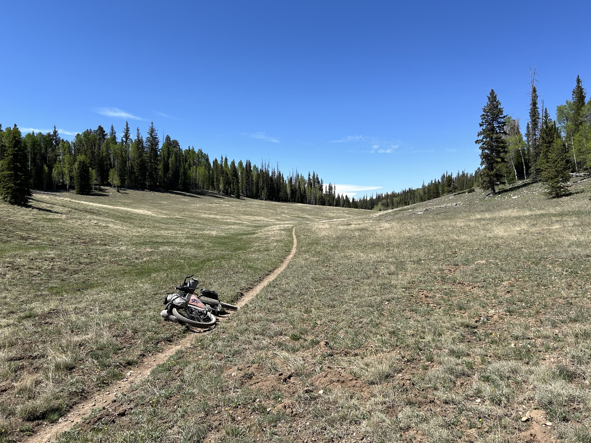
Start the ride at Demotte before a climb up to the Kaibab High Point and a ride on Arizona Trail singletrack across meadows out to Dog Point. Then it's a smooth and beautiful ride through aspen along Dog Saddle Road that takes riders out to Nankoweap/Saddle Mountain Trailhead. Retrace, and then head north out to Marble Viewpoint for one of the best dispersed camping spots on the North Rim. After a night out, head back the way you came and then turn on more AZT singletrack crossing wide subalpine meadows before one last view of the canyon at East Rim Viewpoint. Jump on some smooth dirt roads for a fast descent back to Demotte.
Highlights:
Viewpoints of the Grand Canyon at Dog, Nankoweap/Saddle Mountain, Marble Viewpoint, and East Rim
Riding Arizona Trail singletrack across vast subalpine meadows.
Gorgeous dirt roads that sprawl through large aspen groves
Some of the best water source on the Kaibab Plateau at Crystal Spring and Marble Sinkhole
Views of Baaj Nwaavjo I'tah National Monument, Marble Canyon, Grand Canyon, Navajo Mountain, Vermilion Cliffs, and Grand Staircase-Escalante
3. Map and GPX
-
Purple = Improved Dirt Surface (Frequently Maintained, Usually Smoother)
Red = Rugged Dirt Surface (Infrequently Maintained, Typically Rougher/Rockier)
Black = Singletrack
Blue = Vehicular Pavement


4. Route Difficulty, Surface Conditions, and Direction to Ride
Route Difficulty
Physical Difficulty = 5/10 (Rugged terrain with frequent climbs, some of which may be steep and unrelenting)
Technical Difficulty = 5/10 (Continuous sections of track may be rocky, loose, and steep; (e.g., 4×4 roads or singletrack in rugged/rocky terrain) suitable for intermediate mountain bikers)
The technical difficulty of the route is due to the presence of singletrack along with some rocky portions near Nankoweap/Saddle Mountain.
The physical difficulty is mostly due to the climbing. This is rolling terrain with frequent climbing. Small portions of the AZT singletrack may require hike-a-bike except for the strongest climbers.
Noteworthy Climbs
The climb to the Kaibab High Point.
Heading up the AZT switchbacks towards Dog Point.
Surface Conditions
East Rim Overnighter travels down a mix of Forest Service roads, doubletrack, and singletrack. Most of the dirt roads are regularly maintained, wide, lightly graveled, and sometimes hero dirt. The ride out to Nankoweap/Saddle Mountain can get very rocky, especially after monsoon season. All roads in this area are often littered with tree blowdowns come early summer. The deadfall will get removed, but anyone traveling in the early season may have to go around/over trees until agencies clear them. The Arizona Trail singletrack can be chunky in parts and flowy in other places.
Direction to Ride
The route is intended to be ridden in a clockwise direction.
5. Parking
Park your car overnight at the Kaibab Lodge (contact ahead to get permission - (928) 638-2389, info@KaibabLodge.com), or ride up the route a bit on FR 22 to leave it at a pull-out in the woods.
6. Water and Food
Water Reliability
Water is scarce along this route. The Kaibab National Forest is considered the driest national forest in the United States. Although the North Rim is higher than the South Rim and consequently receives an average of 25.8 inches of moisture a year, most quickly percolates through the porous rock of Kaibab Limestone that makes up the upper layers of this area. Plan to carry several liters of water, enough to last you at least 24 hours. Crystal Spring, Marble Sinkhole, and Wildlife Tanks are generally reliable if there has been good snowpack from winter or strong summer monsoons. Carry bonus liters of water just in case any of these are dry. Beyond these sources, water may be found in dirt cattle tanks, unlisted springs, and unreliable seasonal creeks. This route requires riders to dry camp.
Food Resupplies
Food resupplies are located at the start/finish in Demotte only.
7. Fees and Permits
Kaibab National Forest has no fees.
8. Important Information
Hunting Season:
Starts in September and goes through December. Hunters will mostly be seeking deer and elk. Expect to see more trucks, backcountry campers, ATVs, and individuals on foot. WEAR ORANGE and make yourself visible as you ride. Be smart and be seen during hunting season. Wildlife Tanks may have more hunters scoping them out.
Bugs:
Mosquitoes and biting flies can be abundant on this route in the forest valleys and drainages where moisture and standing water collect. This will be especially true in the summer and early fall, especially if precipitation has been plentiful.
Dark Skies:
Grand Canyon National Park is an International Dark Sky Park. This means that you can expect to have anywhere between Bortle Class 1 - 3 night skies overhead (even better night viewing during a new moon). The Bortle Class Scale is used to rate night skies on their clarity and lack of light pollution. A Bortle Class 1 is the darkest possible and there are several locations along these routes where, should you camp, you will have this level of darkness. Here, night skies will be virtually unimpeded by artificial light. You can use the following sites to explore more:
Black Bears:
There are black bears which means you need to properly store your food at night using a bear-aware method.
Fences:
There may be "cowboy fences" on this route which consist of barbed wire wrapped around vertical wooden branches that are strung across roads. They can be opened by removing a loop of wire on one side. Most importantly, leave fences as you found them; re-close them if they were closed.
Hantavirus and Plague:
Bubonic plague and hantavirus are frequent enough amongst the rodent population that you should avoid their saliva, feces, urine, and direct bodily contact. Be careful when entering old cabins and caves where droppings are plentiful and ventilation is limited. These are prime areas for possible contraction of these diseases.
9. General Access and Tribal Nations
You are allowed to cycle on any established dirt roads.
Bikes are STRICTLY forbidden below the rim in the inner gorge of the Grand Canyon. DO NOT RIDE YOUR BIKE DOWN INTO THE CANYON - you will get fined, it is illegal, and you will hurt the perception and opportunities of other bikepackers on this route. Practicing Leave No Trace means staying on established trails, roads, and paths.
I must note that although this route stays on "public lands," the formation of Grand Canyon National Park and surrounding land designations involved the forced removal of tribes such as the Havasupai, and they have endured legal battles to keep their vastly smaller chunk of land out of their historical precedent. Know the land you are riding on is traditionally theirs, know their current reservation boundaries are smaller than where they historically inhabited, and know where you are riding to keep yourself both legal and respectful.
10. Camping
In the Kaibab National Forest, excellent and numerous dispersed camping abounds. The North Rim is truly one of the most remarkable places for dispersed camping right up against the edge of the Canyon at numerous locations for those making the remote trek out. I highly suggest spending the night dispersed camped at any of the capes along the rim.
11. Sample Route Itinerary
This is a suggested itinerary. Use it as a rough guide for your own planning purposes. Feel free to use it, adapt it, or don't use it all and make your own plans. Plan your trip on this route based on your own strengths, comfortabilities, experiences, wants, and needs.
-
Mileage: 47 Miles
Elevation Gain: 3500 Feet
Water: Marble Sinkhole
Resupply: None
Camping: Dispersed camping at Marble Viewpoint
-
Mileage: 19 Miles
Elevation Gain: 1200 Feet
Water: Crystal Spring; Wildlife Tank, Demotte
Resupply: North Rim Country Store or Kaibab Lodge
Camping: Finish! Demotte Campground, Kaibab Lodge, Dispersed Camping in the woods nearby